Content

Photo by Ken Dewey
Last Month's Data, September 2026 Next Month's Data, November 2026
Our Social Media weather/climate updates
Twitter (X)
Facebook
Bluesky:
FALL Colors:
Fall 2026 Colors Photo Gallery ONE AND Gallery TWO AND Gallery THREE
Fall 2025 Colors Photo Gallery ONE AND Gallery TWO AND Gallery THREE
Fall 2024 Colors Photo Gallery ONE AND Gallery TWO
Progression of Fall Colors in the U.S.
October 1997 Lincoln Record snowfall our report
October 1997 Snowstorm NWS Report
October 1997 Snowstorm Newspaper report
NEW LINK: Lincoln NE, October Snowfalls
NEW LINK: Lincoln's First Snow After Summer, Climatology
RECORDS:
Record high temperature October 9, 2026: 92°F (old record 90°F set in 1928 & 1921)
Tied record high temperature, October 10, 2026: 91°F (originally set in 2024, 1963, 1931, 1928)
Record high temperature, October 12, 2026: 94°F (old record 93°F set in 1975) and warmest for so late in the year.
NEW: LIST of all Records set this current Year
Top 11 October Average Temperatures (1887-2026)

Year 2026 (and last year) Lincoln precipitation (inches), rain + melted snow
| JAN | FEB | MAR | APR | MAY | JUN | JUL | AUG | SEP | OCT | NOV | DEC | TOTAL | |
| Normal | 0.73 | 0.89 | 1.55 | 2.69 | 4.91 | 4.48 | 3.25 | 3.32 | 2.90 | 2.14 | 1.30 | 1.18 | 29.34 |
| 2026 | 0.95 | 0.44 | 0.22 | 2.47 | 4.65 | 4.09 | 6.78 | 4.75 | 11.49 | 1.29 | 37.13 | ||
| 2025 | 0.10 | 0.31 | 0.95 | 1.71 | 3.05 | 3.22 | 3.93 | 4.89 | 3.53 | 1.94 | 0.61 | 0.25 | 24.49 |
Normal January 1 - September 30 Precipitation = 24.72 inches
Normal January 1 - October 31 Precipitation = 26.86 inches
Lincoln's October 2026 Sun data
October 1: Sunrise 7:23 am; Sunset 7:08 pm, Daylight: 11 hours, 45 min
October 31: Sunrise 7:56 am; Sunset 6:23 pm, Daylight: 10 hours, 27 min
Lincoln's Halloween Climatology
Lincoln's Earliest Snowfalls in Autumn
First freeze following Summer, 1887-2025
Growing Season Data, 1887-2025
Last freeze following Winter 1887-2026
Lincoln's hot weather climatology

All data in the following tables are from the National Weather Service and HPRCC data archives.
| October | 2026 | Max | Min | Mean | Dep | Pcpn | Rec Pcpn | Rec Max | Rec Min | HDD | CDD | Norm Max | Norm Min | Norm Mean | Snow |
|---|---|---|---|---|---|---|---|---|---|---|---|---|---|---|---|
| Thursday | Oct. 1 | 69 | 50 | 60 | -1 | T | 2.83 | 94 | 27 | 5 | 0 | 74 | 48 | 61 | . |
| Friday | Oct. 2 | 70 | 45 | 58 | -2 | 0.00 | 1.28 | 94 | 28 | 7 | 0 | 74 | 47 | 60 | . |
| Saturday | Oct. 3 | 78 | 46 | 62 | +2 | 0.00 | 2.10 | 96 | 27 | 3 | 0 | 73 | 47 | 60 | . |
| Sunday | Oct. 4 | 76 | 48 | 62 | +2 | 0.00 | 1.20 | 93 | 29 | 3 | 0 | 73 | 46 | 60 | . |
| Monday | Oct. 5 | 78 | 45 | 62 | +3 | 0.00 | 1.34 | 98 | 28 | 3 | 0 | 72 | 46 | 59 | . |
| Tuesday | Oct. 6 | 89 | 52 | 71 | +12 | 0.00 | 1.33 | 93 | 24 | 0 | 6 | 72 | 45 | 59 | . |
| Wednesday | Oct. 7 | 84 | 51 | 68 | +10 | 0.00 | 1.18 | 90 | 20 | 0 | 3 | 71 | 45 | 58 | . |
| Thursday | Oct. 8 | 86 | 47 | 67 | +9 | 0.00 | 1.79 | 91 | 17 | 0 | 2 | 71 | 45 | 58 | . |
| Friday | Oct. 9 | 92 | 58 | 75 | +18 | 0.00 | 1.73 | 92 | 18 | 0 | 10 | 70 | 44 | 57 | . |
| Saturday | Oct. 10 | 91 | 64 | 78 | +21 | 0.00 | 2.26 | 91 | 23 | 0 | 13 | 70 | 44 | 57 | . |
| Sunday | Oct. 11 | 91 | 65 | 78 | +22 | 0.00 | 2.74 | 94 | 21 | 0 | 13 | 69 | 43 | 56 | . |
| Monday | Oct. 12 | 94 | 56 | 75 | +19 | T | 2.59 | 94 | 21 | 0 | 10 | 69 | 43 | 56 | . |
| Tuesday | Oct. 13 | 59 | 46 | 53 | -2 | 0.00 | 1.13 | 92 | 22 | 12 | 0 | 68 | 42 | 55 | . |
| Wednesday | Oct. 14 | 62 | 46 | 54 | -1 | 0.00 | 0.86 | 91 | 24 | 11 | 0 | 68 | 42 | 55 | . |
| Thursday | Oct. 15 | 57 | 46 | 52 | -2 | 0.74 | 1.12 | 91 | 22 | 13 | 0 | 67 | 41 | 54 | . |
| Friday | Oct. 16 | 56 | 34 | 45 | -9 | 0.00 | 1.74 | 88 | 21 | 20 | 0 | 67 | 41 | 54 | . |
| Saturday | Oct. 17 | 62 | 31 | 47 | 6 | 0.00 | 1.18 | 85 | 15 | 18 | 0 | 66 | 41 | 53 | . |
| Sunday | Oct. 18 | 70 | 42 | 56 | +3 | 0.00 | 1.27 | 87 | 18 | 9 | 0 | 66 | 40 | 53 | . |
| Monday | Oct. 19 | 72 | 42 | 58 | +6 | 0.00 | 1.02 | 88 | 12 | 7 | 0 | 65 | 40 | 52 | . |
| Tuesday | Oct. 20 | 75 | 40 | 53 | +1 | T | 0.46 | 90 | 18 | 12 | 0 | 65 | 39 | 52 | . |
| Wednesday | Oct. 21 | 79 | 52 | 66 | +15 | 0.02 | 0.75 | 89 | 20 | 0 | 1 | 64 | 39 | 51 | . |
| Thursday | Oct. 22 | 80 | 51 | 66 | +15 | 0.00 | 2.01 | 89 | 19 | 0 | 1 | 64 | 38 | 51 | . |
| Friday | Oct. 23 | 82 | 57 | 70 | +19 | 0.00 | 1.18 | 89 | 20 | 0 | 5 | 63 | 38 | 51 | . |
| Saturday | Oct. 24 | 79 | 51 | 65 | +19 | 0.00 | 1.50 | 89 | 17 | 0 | 0 | 63 | 38 | 50 | . |
| Sunday | Oct. 25 | 71 | 48 | 60 | +10 | T | 2.19 | 89 | 15 | 5 | 0 | 62 | 37 | 50 | . |
| Monday | Oct. 26 | 69 | 49 | 59 | +10 | 0.02 | 1.57 | 86 | 19 | 6 | 0 | 62 | 37 | 49 | . |
| Tuesday | Oct. 27 | 61 | 50 | 56 | +7 | 0.01 | 1.62 | 89 | 8 | 9 | 0 | 61 | 36 | 49 | . |
| Wednesday | Oct. 28 | 80 | 52 | 66 | +18 | T | 1.56 | 84 | 10 | 1 | 0 | 61 | 36 | 48 | . |
| Thursday | Oct. 29 | 70 | 44 | 57 | +9 | T | 1.98 | 87 | 9 | 8 | 0 | 60 | 35 | 48 | . |
| Friday | Oct. 30 | 68 | 55 | 62 | +15 | 0.40 | 4.07 | 83 | 3 | 3 | 0 | 60 | 35 | 47 | . |
| Saturday | Oct. 31 | 65 | 59 | 62 | +15 | 0.10 | 2.07 | 83 | 11 | 3 | 0 | 59 | 34 | 47 | . |
| October | 2026 | Max | Min | Mean | Dep | Pcpn | Rec Pcpn | Rec Max | Rec Min | HDD | CDD | Avg Max | Avg Min | Avg Mean | |
| . | TOTAL | 1.29 | 153 | 65 | 0.0 | ||||||||||
| . | AVERAGE | 74.70 | 49.1 | 61.9 | |||||||||||
| NORMAL | 66.6 | 41.0 | 53.8 | 2.14 | 367 | 20 | 0.9 | ||||||||
| . | DEPARTURE | +8,1 | +8.1 | +8.1 | 0.85 | -214 | +45 | -0.9 |
AVERAGE AND TOTAL are OCTOBER 2026.
Temperature is "degrees F"
Precipitation measurement is "inches"
Precipitation "T" = trace, precipitation was observed but not enough to be measured
NORMAL (Norm) refers to the 1991-2020 Standard normals.
DEPARTURE is OCTOBER 2026 Averages and totals measured against 1991-2020 Normals.
Max = Observed Maximum and Min = Observed Minimum temperatures in °F.
Mean = Observed Mean Daily temperature in °F.
Dep = Departure from normal (- is below normal, + is above normal, in °F.
Pcpn = Observed daily precipitation (midnight to midnight, CST) in inches.
Rec Pcpn = Record daily amount of precipitation in inches.
Rec Max = Record maximum temperature in °F.
Rec Min = Record Minimum temperature in °F.
HDD = heating degree day units (base of 65 degrees) in °F.
CDD = cooling degree day units (base of 65 degrees) in °F.
Norm Max = Daily Normal High Temperature (1991-2020 normals) in °F.
Norm Min = Daily Normal Low Temperature (1991-2020 normals) in °F.
Norm Mean = Daily Normal Mean Temperature (1991-2020 normals) in °F.
Snow = Snowfall in inches.
From the record books:
Wettest October: 5.40 inches, 1986
Driest October: 0.00 inches, 1952
Hottest recorded October temperature, 98°F, October 5, 1947
Coldest recorded October temperature, 3°F, October 30, 1925
SNOWFALL (129 years, 1897-2025):
Earliest ever first snowfall, September 28, 1985, 0.8 inches.
Most ever October snowfall, 13.2 inches, October 26, 1997.
Octobers with measurable snowfall (1897-2025) 22 years since 1900 (21/129 years = 17%)
Octobers without measurable snowfall (1897-2025) 106 years since 1900 (104/129 years = 83%)
The last October measurable snowfall was in October 2020
NEW LINK: Lincoln NE, October Snowfalls
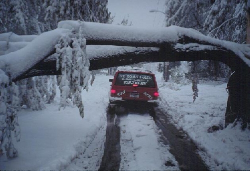
The yellow "do not pass" line is ignored as we wind our way through
the tree covered streets of Lincoln on October 25, 1997
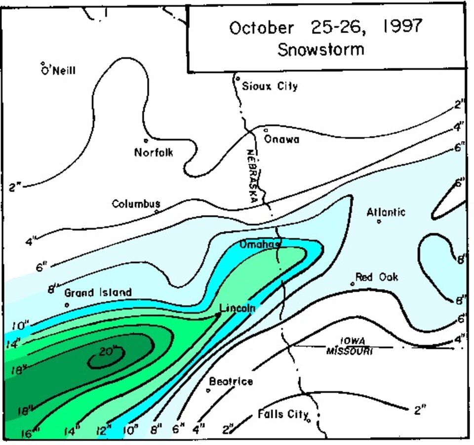
Map of October 25-26, 1997 Snowstorm
October 10, 2009 LINK: Third Earliest Snowfall for Lincoln, NE
NOTE: All data on this page are from the National Weather Service and HPRCC data archives.